Monday, 2 April 2012

On the Road, Wanaka to Queenstown

We left the West Coast to head inland towards Queenstown. We made our way (slowly) up the Haast Pass, 562m above sea level, this sits about a third of the way up the South Island just a short way inland from the Coast.  After starting our descent from the pass we soon found ourselves straddling two beautiful lakes, Lake Wanaka and the Lake Hawea.  The sun was out in full effect and this made for some of the most picturesque driving we have done in our three weeks so far in New Zealand.  The lakes in the South Island are all formed from remnants of long ago glaciers (NZ was in an ice age just 12,000 years ago) so the waters are incredibly clear and shimmer in the sunlight.  With the surrounding mountains rising high at the lake edges it makes for some incredible scenery.


Not too far down the road we arrived at the town of Wanaka, situated at the bottom of the lake of the same name.  In Wanaka we decided to tackle the suitably named Puzzle World.  This included an outdoor three dimensional maze with over 1.5km of walkway, we must have covered about 5km though by the time we came out!  Inside they also had a whole array of puzzling rooms, from the Following Faces room to the balance loosing Tilted Room, and even a Leaning Tower of Wanaka outside, leaning at a crazy 54 degrees.  We spent the night just outside of town in a council campground, we thought we might get away with a free nights camp but were awoken in the early hours with a knock knock on the front window!


The following day we set off for Queenstown but faced a difficult choice.  To go round the mountain or over the mountain.  Going round the mountain would mean sticking to the highway but taking 110km.  Whereas going over the mountain on the Crown Range Pass meant some very steep and windy roads and most likely a lot of second gear crawling, but only 67km of road.  We choose the latter.  Opened in 2000 the Crown Range Pass is New Zealands highest tarmaced road some 1080m above sea level.  With some solid high rev low gear driving we just about made it to the top to appreciate the views before rolling down the otherside to Queenstown.


Queenstown sits on the stunningly clear Lake Wakatipu and is hemmed in by several mountain ranges including the well named 'Remarkables' range.  Queenstown takes its name from its founding when it was deemed to be a location 'fit for the Queen', and the Remarkables mountain range from the fact that they were viewed as 'quite remarkable'.  Queenstown is still quite a small town, the population is listed as less than 15,000 but it is the selfstyled activity hub of New Zealand.  There are over 200 different activities to try your hand at from the high octane; sky dive, bungee, rafting, to the more obscure frisbee golf.  That's nearly one for every working day of the year.  (Not that we know much about that anymore, we've pretty much lost track of days of the week now).  By day the skies over the Gondola are peppered with paragliders drifting over town.  Plenty to think about, and plenty to keep you occupied if you have the money.  However a relatively small town out of the young crowd you find everyone munching on a takeaway humongous Fergburger or with an activity number scribbled on their hand in permanent marker. We could definitely spy the above while lazing around on the grass listening to some live music at the Saturday market.


Queenstown also has some stunning gardens which edge out into the Lake Wakatipu on a small peninsular.  Its here that we can really start to feel the changing of the seasons, although its generally been warm and sunny during the daytime, when the suns not out and during the evening you can quickly feel the chill, and two pairs of socks is often a neccessity.  The leaves on the trees are starting to turn brown and some are already falling as Autumn takes hold, a season we should of been entering six months ago back in October when we left the UK for the Southern Hemisphere.  It feels like a good time to visit Queenstown as the large influx of tourists and campervans is on the decline but the weather is still on the nicer side.  However in such a setting its easy to imagine Queenstown as a stunning setting in every season.


The Wet Coast

We awoke our first morning in the South Island in a deserted DOC campground.  After a bite to eat we were back on the road and aiming for our next destination, the South Islands famed West Coast.

After some very deserted long and windy roads through some very foggy weather we arrived at the Tasman Sea.  Fortunately for us we had made our way out of the bad weather and found ourselves crusing along the coast road in the blazing sunshine.  Making our way south along the coast you could take your pick of the beauty spots for lunch, and we chose a cracker along a gorgeous stretch of uninhabited beach.  Before long we arrived at the small town of Punakaiki, home to the so called Pancake Rocks.  These rocks have been formed over millions of years, and have resulted in the most extreme form of sediment layering.  Hence their name as the Pancake Rocks.


The weather was still holding out pretty nicely by the time we arrived to our next camp ground,  but despite it being a nice enough evening it was a bit on the cold side for a dip in the lake.  We were however joined by some very inquisitive kiwiesque flightless birds who seemed very interesting in getting their beaks into our cuppa soup.  I guess everyone needs a great big hug in a mug.  We are feeling the cold in the South Island more and more, each hundred kilometers or so further we go the colder it gets after the sun has gone down.  Seasonwise Its the polar opposite to the UK, we are exactly 12 hours time difference, and right now we are fast approaching the middle of Autumn.


Expecting to wake up to more sunshine we were dissapointed by a downpour which was to last for around 24 hours.  We headed into the town of Hokitika, and hunting for some dry indoor activites (by this time the downpour was torrential) we happened upon the Jade Museum.  The town is famous for its Jade and Greenstone and gave us a good hour or so inside to see some live carving and wander the workshops.  With a break in the rain we decided to brave it and head further south towards the Franz Josef Glacier.  A short 50km drive took forever as we had to pull over several times as the level of rain coming down was so horrendous, and the lowlying fog meant you couldn't see to the end of the one-lane bridges to give way even if you wanted to.  These one-lane bridges are everywhere in this part of New Zealand, we did 20 in one morning, whats wrong with a good old two lane bridge.

The following day we saw the Franz Josef Glacier.  A short 30 minute walk from the town brings you to the face of the glacier.  The glacier offered nothing of the grandeur or splendour of the glaciers we saw in South America but they made for a good day out all the same.  Here we had our first mechanical trouble as Marv decided he had had enough, but (fortunately) we were parked in the visitors centre car park so we weren't stranded in the middle of nowhere.  With a bit of persistence and good kick we were able to get Marvin running again and made the 30km uphill and subsequent downhill slalom through some extreme rains to the nearby Fox Glacier.  Without wanting to be all glaciered out we decided to leave the Fox Glacier for the following day.  We instead made for the nearby Lake Matheson which would normally offer splendid mirror like reflections of Mt Cook and Mt Tasman in the background.  However half way round the lake the heavens re-opened and with at least 30 minutes to the nearest form of shelter we took an absolute soaking.  Adam more so for claiming before setting out that there would be no need to take a rain jacket.  The even more unfortunate consequence of this is that we failed to be able to see anything in the reflection of the lake, in fact we could hardly make out the otherside of the lake.


The weather here in New Zealand can be extreme, extremities we can handle but the speed in which it can swing between opposites is alarming.  The almost instantaneous change in the weather can be your best friend (when its raining) to your worst enemy (when it starts to rain out of nowhere).  More often than not though the change in weather will catch you out for the worst, and nowhere more so than here on the South Islands West Coast.  The West Coast gets six times more rain than London, and ranks as one of the wettest habitated places on the planet.  It rains more than two out of every three days.

That night we took a wander down to a forest walk that was a home to thousands of glowworms.  Expecting a cave in which to enter we walked the length of this 20 minute trail in the dark with nothing but a flash light and found not a glimpse of any cave in which the glowworms might be dwelling.  Just as we were about to admit defeat and head back to the campsite we established (with a bit of help) that the glowworms didn't reside in a cave but in fact had set up home in amongst the wet moss of the trees.  By turning the flashlight off and with a keen eye we could soon make out a lot of small but bright (for their size) glowworms hanging from the tree's.  That night we were based between the two glaciers in what was without doubt the coldest night we have had not just in New Zealand but on our whole trip, colder than Machu Picchu, the Bolivian Salt Flats or Chilean Patagonia.  The Uniqlo thermal underwear is starting to pay for itself now, as we were wrapped up fully clothed under sheet, duvet, blanket and sleeping bags and still cold!

The following morning however we were blessed with some clear skies and some great views of Mt Cook and Mt Tasman.  After taking Marv to get a look over at the only mechanics in town, (the Fox Glacier Village is tiny) we made for the star attraction, the Fox Glacier.  Again it was nice to see but compared to the Perito Merino and Viedma in Argentina it was a bit of a pale comparison.  What was interesting however was the rate at which the Glacier is retreating, as you approach the glacier you pass signs such as "in 1750 the glacier was here" and so on.  Since 1930 the glacier has retreated around a kilometer and stood at what is now the visitors car park! 


After a short stay at the glacier we started to make our way towards the Haast Pass some 560m up from us at sea level to start our route inland....

Saturday, 31 March 2012

To Wellington and beyond....

We knew we needed to get a move on to make sure we had a chance to see some of Wellington before moving down to the South Island.  Without a day to spare we headed south for the small town of Otaki.  We had a couple of hundred kilometers to complete and were covering good ground.... until the wind picked up.  Marvins age and height means you end up feeling the wind more inside than you do out.  The consequence of this on the road when trying to keep to 100km/h is a 'small' amount of swaying.  By small, it means you need to keep both hands fully and tightly in the ten to two position on the wheel or you could end up in the Tasman Sea.  Point in case to be made when the local policeman pulled Adam over fearing he may be drunk due to the amount of sideways movement present on an otherwise straight road.

Heeding the nice policemans words we pulled over in the next township about 30km south of our intended destination, Otaki.  We thought quite long and hard about staying here for the night rather than risking too much in taking on the strong New Zealand cross winds.  After a while however it seemed to have calmed a little and we continued further south.  Without affording Otaki too much time we spent the night at the DOC (Department of Conservation) campsite for the night before making our way down to Wellington.

The approach to Wellington was somewhat difficult conditions again, the wind had died down but the rain was torrential and the fog so low that the visibility was almost non existent.  The road to Wellington meanders and bends along the coast, we however could only just make out the oncoming the traffic let alone the views.  In the fleeting moments when the fog rose the journey was however lit by some stunning rainbows.  With only 80km to do that morning we made it to Wellington around 11am giving us just over 24 hours in which to take in the sights and sounds of New Zealands capital city.  Fortunately we found the ideally located Wellington Waterfront Motorhome which is right in the center of town (on the waterfront duh) next to our ferry terminal.


The weather was much the same in Wellington, unable to see the tops of the buildings through the fog we thought best to make for some indoor activities.  First up was the national museum, Te Papa.  Te Papa is like a cross between the science and the national history museums in London (like these it's also free!).  Before we knew it was close to four hours in there and we had seen everything from the forming of the continent millions of years ago, all imaginable species of (stuffed) kiwis (the animal not the people), the worlds biggest squid, a complete history of the Maori and their culture and even experienced an earthquake simulation.  On leaving Te Papa the rains had at least stopped temporarily and we were able to spend some time walking around the main district of Wellington city centre, including a viewing of the controversial 'bee-hive' government building.


The following morning was again more of the same weather wise, grey overcast cloudy and foggy, the first time in six months that it had felt like being back in London!  Quicker than you can say 'Michael Fish' the weather had cleared up and we could at last (in our last hour in the city) be able to see across the harbour as we were afforded some blue skies.  Alas it was time to board our ferry for the South Island, but hoping the blue skies would endure for our crossing.


The trip is a long three and a bit hours for what seems like a narrow stretch of water.  It feels however almost cruise like as you take in the views looking back on Wellington, of the Tasman Sea on one side and the Pacific Ocean on the other.  On our approach to the South Island we were greeted by a playful troop of five or so dolphins frolicking about, racing alongside the ferry, and generally showing off by jumping in and out of the water.  Most people say the South Island is more beautiful than the North (we'll be reserving judgement till the end of our trip), arrival is a good start though as we passed through the fjords of Malborough Sounds, and saw yet more dolphins before arriving into the town of Picton.  From here it was straight back onto the road as we headed through the vineyards for our first night in the South Island.


Friday, 23 March 2012

Corncerning Hobbits.... - Part II

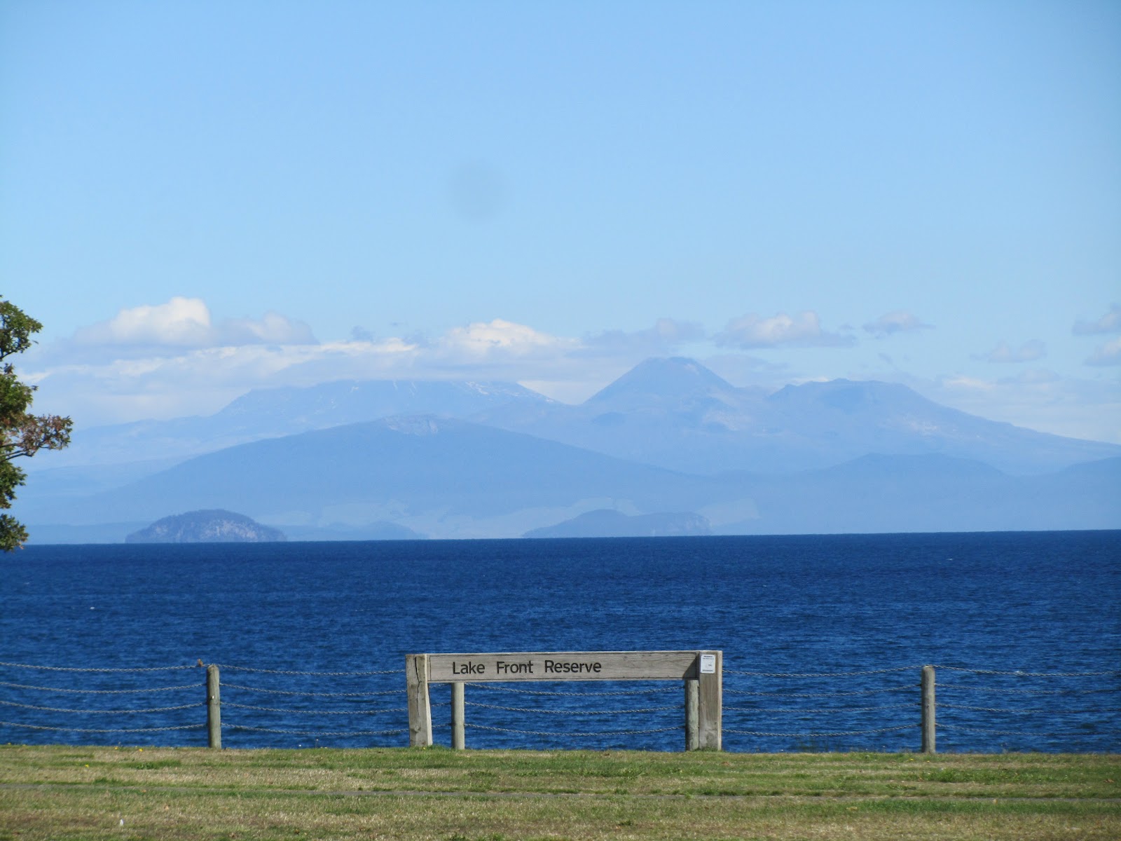
On seeing the volcanoes the other side of Lake Taupo we made our way around the lake, further south and with an ever improving view of the national park.  The Tongariro National Park is New Zealands oldest and houses three unique and incredible volcanic mountains which rise to between 2,000-3,000m.  The self named Mt Tongariro, the highly active Mt Rhuapehu  and  the perfectly conical Mt Ngauruhoe.  Of the most intriguing is probably the latter which doubles up as Mount Doom in the Lord of The Rings trilogy.  Mt Ngauruhoe is just a small peak short of being a perfect cone and on a clear day is an awe inspiring sight.  The taller more active, and often cloudy Mt Rhuapehu is more of a sprawling mass of volcanic rock with several volcanic outlets and was chosen by Peter Jackson to be the fear inspiring scenes of Mordor.


We camped inside the boundaries of the national park and decided to check out Mt Doom from a little closer up.  We took a 17km hike to the Tama lakes, which are two old volcanic craters themselves.   On our way we passed the Taranaki Falls which have carved an impressive cliff into the landscape and continue to erode their way through the park.  What started as an easy stroll in the sun through the forest became a very cold and windy experience up at the top.  We were however rewarded with some great views of the upper and lower lakes as well as the surrounding volcanoes.  This part of the national park also made up a lot of the scenes of Mordor in the film The Return of The King.  As the clouds came in it became easy to imagine 'The Shadow of The East' moving and doesn't take much imagination to recreate the setting.


The following day we stayed in the National Park but made our way further south and spent the night at the small town of Ohakune.  Nestled just within the National Park but not far from a major highway Ohakune is a sleepy little town which relies heavily on passing trade, and welcomes you with (you guessed it) New Zealands biggest... Carrot.  We however not contributing a great deal to the local community made for the nearest free campsite.  From here we were able to do a nice walk along the Old Coach Road which use to house the main route for the central  New Zealand railway.  After passing through an old long deserted tunnel we arrived at the old viaduct.  No longer deemed as safe for use but fine for tramping tourists we ventured across the 120 year old wooden structure.  The viaduct was in fact the site of New Zealands first commercial bungee jump, however this was closed down aswell due to safety fears.  Needless to say we felt nice and safe walking along the viaduct.


In Ohakune, 400km north of Wellington, we popped into the local library to 'borrow' their wifi and check our emails.  This was when we realised we had prebooked our Cook Straight Ferry for the South Island a day earlier than originally thought... a quick clear up of our stuff and it was time to get on the road again, quickly!

Wednesday, 21 March 2012

Corncerning Hobbits, Rotten Eggs, and Mt Doom - Part I

From Huntley we made our way East through the back roads based on a locals advice.  We cut out the traffic and driving joy of Hamilton city center and instead made for the small town of Matamata on route to the Bay of Plenty.  Matamata should be a small quiet sleepy town in the central north island farm territory.  However the selection of this town to be Peter Jacksons 'Hobbiton' has transformed the town.  There's now a wide choice between KFC, McDonalds or Subway, and enough coach parking to fill half of Wembley.  We like all the other tourists passed through for a glimpse of this cinematic piece of history.  On route here it was very easy to see how this area could be turned into a part of The Shire.  There are small rolling hills throughout the countryside any one of which look like they could be selected for a film set.


From Hobbiton we made our way South to the larger town of Rotorua.  Rotorua goes by the name of 'Sulphur City' and to quote Mikey 'you can basically let one rip here and noone would ever know'.  Too true, the  city absolutely stinks of rotten eggs.  Rotorua is built on one of the biggest natural sulphur vents in the world.  The local park has bubbling mud pools, steaming eggy geysers and some hot pools you can soak your feet in.  These pools are said to have healing powers by the local Maori of old.  We tested them out but not having any injuries to speak of can't really comment on their healing powers, they were nice and warm though.


After a bit of time in Rotorua admirring the lake and local activites it was time to make a move before the smell started penetrating into our hair and clothes permenantly.  We are free camping as much as possible so nice hot showers are a bit few and far between at the moment.  That evening we headed South 20km to a beautiful free campsite which was on route to our next destination.  With only three other vehicles in the whole site we had a great lakeside view to bed down for the night.


The following morning we set of early for the nearby attraction of Wai-O-Tapu.  We are following the 'Thermal Highway' south at the moment which cuts diagonally (from NE to SW) down through the North Island, so there is no shortage of geothermal activity to be seen.  Wai-O-Tapu however  is supposed to be one of the best and is also home to the Lady Knox geyser.  We arrived early in the morning to ensure we could see her spurt sulpherous water 30 ft into the air.  Outside of the geyser we saw around 40 other geothermal active sites including the awesomly huge 'Champagne Pool'.  A massive steaming circular shaped pool with lots of red and yellow mineral based influences.  Of the other notable  highlights was without doubt the 'Devils Bath' a large pool with what can only be described as a lime green liquid filling it.  Again a natural mineral infusion has occured with some pretty unique visual results.


Heading further South we spent the night at another free campsite.  No showers, but it was on a (very cold) river which allowed for at least a partial wash.


We continued our route south to the city of Taupo.  Taupo is on the lake of the same name, which also happens to be the largest lake in New Zealand.  No matter where we go in New Zealand we never seem to be far from "NZ's biggest... NZ's oldest... or NZ's longest", its nice to recognize your achievements.  Lake Taupo is the crater filled result of one the biggest volcanic eruptions in history some 26,500 years ago.  Its a pretty big lake.  It was also clear blue sky with beautiful sunshine whilst we were there, so we spent some time down by the lake watching some paragliding and playing some mini golf (I won't mention who won).


In the distance across the lake we could just make out the Tongarrio National Park and its skyline dominating volcanoes, our next destination...

Tuesday, 20 March 2012

The Lands of the North

We set off north from Auckland just after 2pm on what was a cloudy but dry afternoon. After picking up Marv and filling him with supplies from the local Pak 'n' Save supermarket we set off over the bridge at into The Northlands. A few nervous and jolty gear changes later (to say the least) we were on our way (just about). If driving a vehicle of Marvs height weight and general size was daunting at least driving on the left was a welcome relief.

Our aim was to make it up to the Bay of Islands before nightfall, approx 200km. Feeling quietly confident in our own abilities and knowing it was only 200km we made a few stops at some stunning locations along the way, including the beautiful Mangawhai Heads and Waipu Cove. (Although the British influence is massive a lot of the locations outside the big cities have retained their original Maori names). Our over confidence and lack of appreciation for smaller NZ roads had us struggling in the darkness around 8pm still looking in vain for somewhere to rest. Around 9pm, after an hours driving in the darkness (no street lights on these roads) and in the now thundery rain we made it to Puriri Bay and our first nights resting point. To make matters worse we hadn't unpacked our backpacks yet or made the bed up before so it was a bit of a first night struggle. We vowed not to undertake the small NZ roads in the dark again after our first night baptism of fire.


When morning came things were looking much rosier and we could at least see where we were, and awoke greeted by a rainbow across the bay. We set off though in search of the nearby Bay of Islands and visited Russell before taking the ferry over to the stunning Paihia. Here we filled the van up and Marv really got his name as Starving Marvin as he guzzled 50 litres worth, where it costs $2.20 NZD (£1.15) a litre, we had a realisation that it will cost us a few quid more than we first thought to get around the country.


From the East coast we cut across country to the West and made our way along the ocean roads. Driving alongside the beach lined coast was a great experience but the strong winds needed two hands on the wheel to keep from veering off to one side! After a short while we entered the forests where some very narrow and windy roads had us literally slaloming through the trees. We arrived at the (aptly named) Kauri forest, home to the Kauri tree. These trees are absolutely humongous and we checked out the largest tree in NZ, over 2000 years old and with a girth of 13.8 metres (that's some big girth).


This was Day 2 in the van, and on animal watch we had seen hundreds of cows, nearly as many sheep, and an untold amount of little birdies, along with a multitude of various roadkills. We saw our first kiwi, as it went darting across the road (lucky spot for us as their numbers are dwindling and are nocturnal animals), had a falcon fly out the forest and into our windscreen (luckily he bounced right off, and we're pretty sure he was alright), and had to pull over and wait for 200 cows to meander slowly across the road.


The following day we took in the sights of the Kauri Museum to get a better understanding of these ridiculously oversized trees. Many of them were cut down a century ago but fortunately they now have a preserved status. From here we continued South back past Auckland at it's four lane highway mayhem and out the other side to the sleepy town of Huntly were we spent the night at a nice campsite beside a lake.


These first few days have given us a chance to get use to the intricies of our campervan, but also a very different form of travelling to which we undertook in South America. We are out on the open road driving ourselves with the freedom to go and stop where we want, but also the privacy that sharing a 12 bed dorm just doesn't allow for.